Last update: September 15, 2025
This page contains information about some of the data available in the FEWS NET Data Explorer (FDE) for Lesotho. This is not a comprehensive guide.
For information about using the filters and fields for specific domains in the FDE, see Choose a Data Domain .
Summary table
|
ISO 3166-1 codes |
Alpha 2: LS, Alpha 3: LSO, Numeric: 426 |
|---|---|
|
Administrative units |
District, constituency, community council |
|
Agricultural seasons |
Main (Aug - Jan), Off-season (Feb - July) |
|
Major crops |
Maize, beans, sorghum |
Country food security context
About two-thirds of Lesotho’s 2.4 million people live in rural areas. Agriculture is the backbone of the rural economy, with most people in rural areas relying on agriculture as an important source of income.
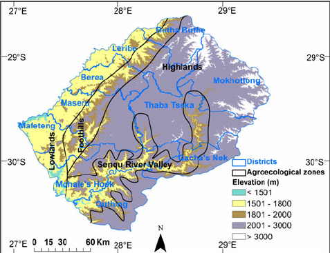
Due to the mountainous terrain only 10 percent of Lesotho’s land is arable. Lesotho’s main agricultural zone is the lowland area in the west (parts of Butha Buthe, Leribe, Berea, Maseru, and Mafeteng districts). Southern Lesotho is often more at risk to the impact of drought and land degradation from erosion, particularly along the Senque River Valley areas of Mohale's Hoek, Quthing, and Qacha's Nek.
Maize is Lesotho’s most important crop (yielding 400-800 tons per hectare), followed by beans, sorghum, wheat, and peas. Cereal production provides less than 30 percent of the country’s staple food needs, with most food imported from South Africa.
Most households obtain food from a combination of cropping, livestock, and purchases using income from labor in agriculture and income from migrant work in South Africa, particularly mining. A third of agricultural households are headed by women. Almost 50 percent of the population earns income through crop cultivation or animal husbandry; however, in the poorest households’ crops are a relatively small source of income. Most Lesotho smallholder farmers produce for their own consumption, with some large commercial farms mostly concentrated in the northern lowlands. In the mountains and foothills, wool and mohair from sheep and goats, along with cattle, are an important source of income.
Statistical reporting units
Lesotho usually uses administrative units as their statistical reporting units.
Administrative (admin) units are the geographical areas into which a country is divided. FEWS NET uses the following terminology: National boundary = admin 0, First sub-national division = admin 1 (e.g., states in the United States), Second sub-national division = admin 2 (e.g., counties in the United States), and so on.
Admin 1: District. There are 10 districts at the first level of administrative division below the national boundary of the Kingdom of Lesotho. They include:
-
Berea
-
Butha-Buthe
-
Leribe
-
Mafeteng
-
Maseru (contains the Kingdom’s capital city)
-
Mohale's Hoek
-
Mokhotlong
-
Qacha's Nek
-
Quthing
-
Thaba-Tseka
Admin 2: Constituency. There are 80 constituencies in the country, ranging in number by district from 3 to 22.
Admin 3: Community Council. There are 129 community councils in the country.
Evolution of Lesotho’s administrative units
Since the country’s independence in 1966, the Kingdom’s ten districts have remained with no changes in their composition.
Crop data
Explore our crop data .
View our documentation on using the Crop Domain .
Crop estimate data sources
The division of Agriculture and Food Security Statistics is responsible for production of agricultural statistics. The division is divided into the following sections; Crops and Food Security Statistics, Livestock and Livestock Products Statistics, Horticulture, Fisheries and Aquaculture Statistics. The agricultural statistics are sourced from the Agricultural Census (AC), Annual Agricultural Production Survey (APS)1, and other relevant ministries and agencies responsible for data collection on agricultural activities.
Although there is an online data portal which offers crop statistics , the holdings are limited in their temporal coverage. Annual crop statistics, going back into the 1980s have generally been made available in publications like the “Annual Production Survey” and the “Crop Forecasting Report”, nominally found via the Publications link under the main menu of the Bureau of Statistics, Ministry of Development Planning . Unfortunately, this website presents only the last few years of the Kingdom’s crop reporting, and at the time this Country Data Book was published, contained, through error, no crop statistic reports at all.
Crop reporting units
Most of the country’s statistical data, including its crop statistics, is reported at the Admin 1-level, the administrative district.
Year and season definition
Agricultural year
The Bureau of Statistics defines the agricultural year in its “ Concepts and Standards ” publication as “a full year that commences on the 1st of August and ends on the 31st of July of the following year”. All annual reporting of the country’s agriculture refers to annual harvests using a two-digit date format (e.g. 2019-2020). This indicates that the reporting includes the Summer crop in a given year, and the Winter crop that follows it in a different year. In the above example, the reporting includes the Summer planting and harvests that occurred between August of 2019 and January 2020, and the Winter planting and harvest that occurred between February and July of 2020.
FDW reporting refers to this annual agricultural year with a single digit year format using the second of the two years given, as is done in much of southern Africa.
Example: 2020 refers to August 1, 2019 - July 31, 2020.
Seasons
There are two meteorological seasons in Lesotho:
-
Summer: August 1 - January 31 in the following year
-
Winter: February 1 - July 31 of the same year
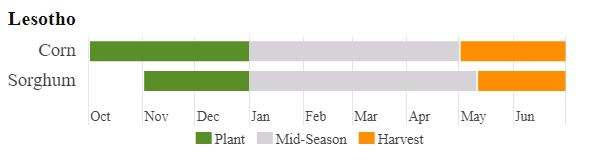
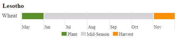
Main season (Summer) planting begins when rains begin, generally in October, and ends before cold temperatures and even frosts are common in April.
Primary crops
The crops represented in Lesotho’s crop statistics include those shown below, with their crop code:
|
DNL Source Crop |
Crop code |
|
Other Crops |
R00000AE |
|
Wheat |
R01112AA |
|
Maize (White) |
R01122AC |
|
Sorghum |
R01142AA |
|
Barley |
R01152AA |
|
Oats |
R01172AA |
|
Beans |
R01701AA |
|
Peas |
R01705AA |
Production systems
Most agriculture in Lesotho is carried out by small-holder farmers, with some scattered small-scale commercial efforts2. Reflecting this, from 1981 through 2018, Lesotho’s crop statistics did not carry any additional production system break-outs, and are coded with the “All production systems” code: “All (PS)”.
Starting in 2019, Ministry of Agriculture surveys began sub-dividing district agriculture production among four different ecological zones, or systems, which have direct (although relatively minor) implications for the types of production systems being utilized in each different zone (see Map below). They are differentiated by altitude, climate, rainfall patterns, and soil properties, influencing their agricultural potential and land use.
-
Lowlands (PS): Characterized by lower elevations, ranging from about 1,400 to 1,800 meters, they have the highest population density and are the most intensively cultivated areas, though they represent a smaller portion of the total land.
-
Foothills (PS): Located at mid-elevations, between the Lowlands and the Mountains.
-
Mountains (PS): The highest and most rugged areas of Lesotho, covering the majority of the country's land area. They are suited for livestock grazing and water resource development but have less agricultural land.
-
Senqu River Valley (PS): This zone is a narrow strip of land along the Senqu (Orange) River, a river that originates in Lesotho. It offers more favorable agricultural conditions.
Crop statistics context
The Lesotho crop statistics found in the FDW cover the period 1981-present. Area measures are given in hectares, and quantities are in kilograms and metric tons. In addition to area planted, area harvested, yield and production, Lesotho also provides area in fallow and area lost to various types of crop failures (which theoretically should equal the difference between area planted and area harvested).
Methodology
The Bureau of Statistics publishes the methodology it uses for annual crop assessments in a document entitled “ Concepts and Classifications for Lesotho, Standard Document .”
1 Annual Production Survey: An annual survey on production of both crops and livestock statistics. This covers both urban and rural areas. Crop production for rural areas focuses on fields while urban production is based on kitchen gardens.
2 The Lesotho Agricultural Census of 2019/2020 assessed commercial farming and livestock operations in a publication titled 2019/2020 Lesotho Agricultural Census Volume III: Commercial Farming Statistics Report .