FEWS NET assigns unique FEWS NET identification numbers (FNIDs) to new geographic units. Having a unique identifier for every geographic unit allows the query of specific geographic units.
FEWS NET uses several types of spatial data, including:
-
Administration Units (A codes)
-
Crop Regions (R codes)
-
Livelihood Zones (L code)
-
Food Security Classification Units (C codes)
-
Markets (M codes)
All geographic units are assigned a unique 10+ digit alpha-numeric FNID. The structure of these codes is explained below:
|
Code Element |
Places Needed |
Description |
|---|---|---|
|
ISO_CODE |
2 Digits |
Standard ISO 2-digit country code |
|
Version (year) |
4 Digits |
The effective year of the geographic unit set version. In general we use the official year when the national government institutionalized new boundaries, not the year when agriculture reporting units changed or the year when FEWS NET received the shapefiles. For markets, use 0000 for the year. |
|
Type |
1 Digit (letter) |
A=Admin unit, C= Food Security Classification, L= Livelihood Zone, R= Crop region, M = Market |
|
Unit level/type |
1 Digit |
For admin units, this is the location in the geographic unit hierarchy; for example, 3 is the level of an Admin 3 unit. For Food Security Classifications, this is the type of classification file where C1=Admin Only, C2=LHZ Only, C3= Admin / LHZ Intersection. For Livelihood Zones, 1 = Zone, 2 = Subzone. For Markets, use 0. |
|
Admin level codes |
2 Digits per level |
Each level is represented by two digits (e.g., 00, 01, 13). At each level, each unit must have a unique ID. Apply this process for as many levels as necessary. See Example 1 below. |
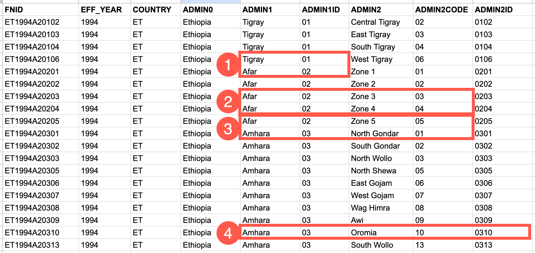
Example 1: Level codes
To create the last part of an FNID, you will need to combine the codes for each relevant level. For example, if you are creating a code for an Admin 3 unit, you will need to combine codes for Admin levels 1, 2, and 3.
Note the following in the image below:
-
Every Admin 1 has its own ID. e.g., Tigray is 01 and Afar is 02
-
Every Admin 2 that falls within an Admin 1 has a unique ID. e.g., Zone 3 is 03, Zone 4 is 04.
-
ID numbering resets when a unit falls under a new unit at the previous level. e.g., Admin 2 ID go from 05 for Zone 5 to 01 for North Gondar because the Admin 1 unit changed from Afar to Amhara.
-
Admin 1 and Admin 2 codes combine to create an Admin 2 ID. e.g., for Oromia, the Admin 1 code is 03, the Admin 2 code is 10. These combine into an Admin 2 ID of 0310. This process should be applied to all necessary levels.
Example 2: Creating a C-type FNID in Afghanistan
In Afghanistan, FEWS NET maps FIC data using the intersection of Admin 2 (districts) and livelihood zones. The FNIDs for these intersect units are structured as follows:
-
Country: AF
-
Year: 2018
-
Type: C
-
Level: 3
-
Kabul admin 2 code: 0101
-
LHZ code: AF08
These are combined to create the following FNID: AF2018C3010108.
Example 3: Market FNIDs
The list below shows a selection of markets in Kenya and their FNIDs.
-
Eldoret: KE0000M002
-
Garissa: KE0000M003
-
Embu-Mberee: KE0000M017
-
Kajiado: KE0000M019
-
Kwale: KE0000M021
-
Laikipia: KE0000M022
Note that all of the FNIDs start with the following:
-
Country: KE
-
Year: 0000 (always used for markets)
-
Type: M (always used for markets)
-
Level: 0 (always used for markets)
The distinction between market FNIDs within a country is made using the last 2 digits.