To map FEWS NET Food Insecurity Classification (FIC) data, FEWS NET uses a C series level coding scheme and shapefiles to map FIC data. Learn more about FEWS NET’s unique ID structure (FNIDs).
There are four types of C series shapefiles used to map FIC data:
-
C1 Admin level: In most cases, the C1 shapefiles should be identical to an administrative shapefile (A series) FEWS NET has cleaned and uploaded either on the website or the FEWS NET Data Warehouse (FDW).
-
C2 Livelihood Zone (LHZ): C2 shapefiles are identical to livelihood zones (L series). This has historically only been used in a few countries.
-
C3 Combined Admin/Livelihood Zone: C3 shapefiles are an intersection of Admin and livelihood zones.
-
C4 Urban Area: C4 urban areas are used when the food security situation is different to the surrounding area, with key drivers that may differ from the surrounding livelihood zone.
The Geographic Unit Set Version should contain a separate layer for each relevant Geographic Unit Type. For example, a FIC shapefile for a country where urban areas are being mapped will likely contain two layers: one layer for the main FIC units, typically the Combined LHZ/Admin intersection units and a second layer containing the urban settlements with polygon or multi-polygon geometry. The complete set of units should form a complete contiguous surface covering the designated boundary for the country.
The layer name must match the unit type using the naming convention <two-digit country code>_<unit_type>_<YYYYY>. In the example of FIC units for Sudan, the FSC Combined Admin/Livelihood Zone layer is named SD_Admin2_LHZ_2026 and the FSC Urban Area is named SD_fsc_urban_2026.
Production of C3 shapefiles
The DSA, country Food Security Analyst, and field staff will discuss the level of Admin unit to be used to map FIC data with the LHZ.
Use the cleaned FEWS NET admin and corresponding LHZ boundaries shapefiles from the FEWS NET GIS verified shapefiles library.
Livelihood zone boundaries are sliced by the district boundaries to create C3 polygons. Clean up and remove slivers, gaps, and overlaps in the polygons using ArcGIS tools such as Union and Identify. All livelihood zone shapefiles should be cleaned as follows:
-
The shapefile polygons should not include any slivers or overlaps.
-
The shapefiles should match up with standard international boundaries.
-
The boundaries for livelihood zones should match with sub-national boundaries where they are intended to do so. Livelihood zone shapefiles produced or coming from the field might not match up with administrative shapefiles in the home office.
-
When creating intersects, a general rule to follow is that all slivers whose area is less than 5% of the parent Admin unit should be merged with a neighboring Admin unit.
Cleaned shapefiles should include the following fields. Additional fields can be added as needed.
|
Field Name |
Type |
Description |
Example |
|---|---|---|---|
|
FNID |
Text |
Unique Alpha-numeric ID (COUNTY + YEAR + “C3” + Admin code + LHZ code). |
AF2018C3010108 |
|
EFF_YEAR |
Short Integer |
Year when the shapefile intersect is being created. |
2018 |
|
COUNTRY |
Text |
2 letter ISO code for the country. |
AF |
|
ADMIN0 |
Text |
Full country name. |
Afghanistan |
|
ADMIN1 |
Text |
Name of Admin 1 in English. |
|
|
ADMIN2 |
Text |
Name of Admin 2 in English, if applicable. |
|
|
LZCODE |
Text |
This should match the LHZ code provided in the LHZ shapefiles. |
|
|
LZNAME |
Text |
This should match the LHZ name provided in the LHZ shapefiles. |
|
|
FNID_OLD |
Text |
If applicable. In most cases, add 0. |
|
|
EFF_PERD |
Integer |
The outlook cycle in which FEWS NET adapted the geographic boundaries (i.e: 1 = February Cycle, 2 = June Cycle, 3 = October Cycle). |
|
Uploading shapefiles
To upload shapefiles in the FDW, follow the steps below:
-
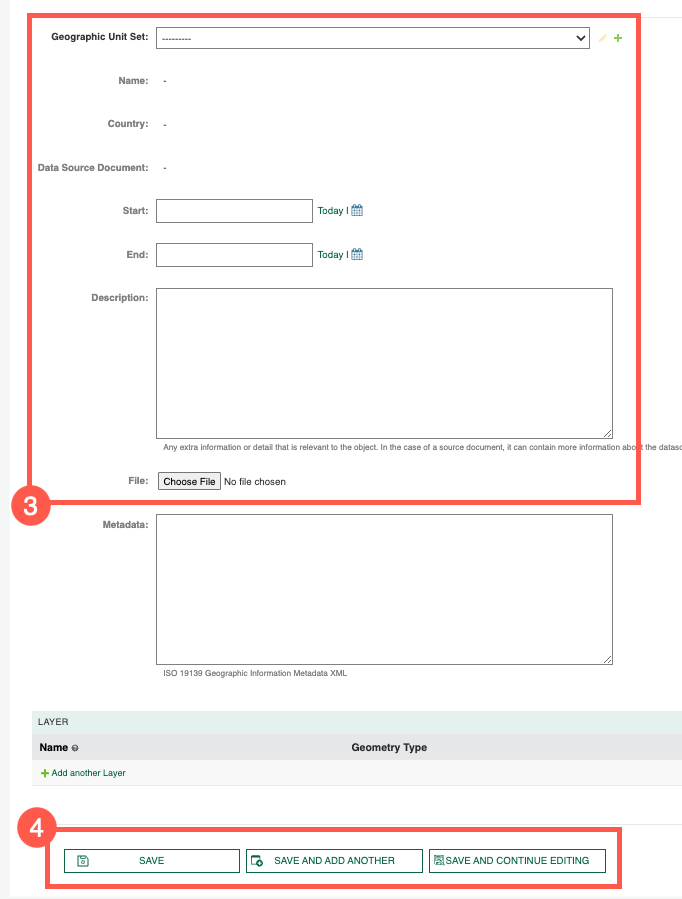
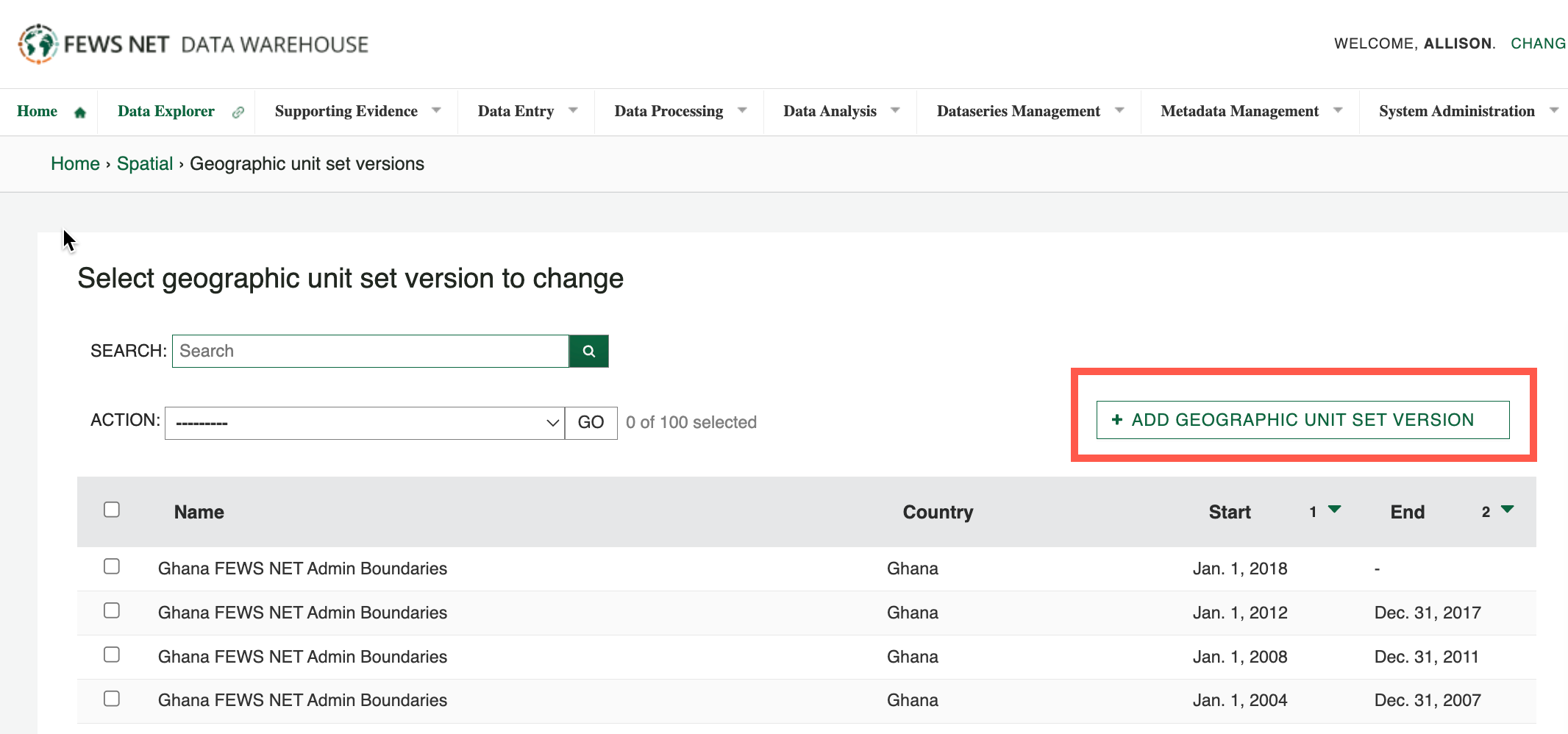
Select Metadata Management > Spatial > Geographic Unit Set Versions.
-
Select the Add Geographic Unit Set Version button.
-
Complete the information as follows:
-
In the Geographic Unit Set dropdown menu, select the items that matches the shapefile Country + FEWS NET Admin Boundaries. For example, Mali FEWS NET Admin Boundaries.
-
The Start and End dates indicate the time period for which the boundaries are in effect. The start/end dates for FIC (Type C) boundaries are determined based on the outlook cycle in which the boundaries started and stopped being used for AFIC mapping. For example, if a set of AFIC boundaries were adopted in the June 2023 outlook cycle the start date would be . If there is no newer shapefile version, the End date is left blank.
-
The effective dates for Geographic Unit Set Versions should not overlap. Before uploading new boundaries, set the end date on the existing boundaries.
-
Click Choose File and select the zipped version of your shapefiles. Shapefiles must be uploaded in a zipped format.
-
Click one of the Save options.