Introduction
Dated: 10 June 2020
The following list of new features, tasks and resolved bugs are included in the latest Sprint 20.05 release:
Features
-
Revisit Crosstab extracts for Crop Production https://fewsnet.atlassian.net/browse/DATA-234
-
Prototype of automated creation of IPC Classification maps https://fewsnet.atlassian.net/browse/DATA-260
-
Create an IPCPhaseMapViewSet https://fewsnet.atlassian.net/browse/DATA-261
-
Return JSON error message for API calls https://fewsnet.atlassian.net/browse/DATA-279
-
Make Layer.geometry_type a ChoiceField https://fewsnet.atlassian.net/browse/DATA-280
-
Make is_staple_food visible through the browseable API and /en/schema-ui interfaces https://fewsnet.atlassian.net/browse/DATA-292
-
Enhanced Geographic Unit Map View in FDE https://fewsnet.atlassian.net/browse/DATA-293
-
Prototype: Interactive Map Visualization for COVID-19 website page https://fewsnet.atlassian.net/browse/DATA-303
-
Add a country_code filter to CountryFilter https://fewsnet.atlassian.net/browse/DATA-310
-
Unaccented search in FDE Geography Filter https://fewsnet.atlassian.net/browse/DATA-321
-
Update all DataSeries subclass Admins to show facts https://fewsnet.atlassian.net/browse/DATA-327
-
Add caching to /api/ipcphasemap https://fewsnet.atlassian.net/browse/DATA-331
Tasks
-
Investigate the completeness of the Geographic Unit Relationships at the Country level https://fewsnet.atlassian.net/browse/DATA-268
-
Remove Search for Crop Production Indicator and Crop Production Indicator Value https://fewsnet.atlassian.net/browse/DATA-286
-
Peak needs API end point https://fewsnet.atlassian.net/browse/DATA-335
-
Covid 19 cases/deaths API end point https://fewsnet.atlassian.net/browse/DATA-336
-
Remove the Search box from the Crop production tab of the FDE https://fewsnet.atlassian.net/browse/DATA-356
Bugs
-
Fix "[invalid name]" filter labels https://fewsnet.atlassian.net/browse/DATA-285
-
Dataset 981 pulling wrong/unknown CPI data https://fewsnet.atlassian.net/browse/DATA-289
-
FDE Spatial map view doesn't work for Kenya FSC Units 2016 https://fewsnet.atlassian.net/browse/DATA-290
-
Spatial view has unusual behaviour around selected Versionshttps://fewsnet.atlassian.net/browse/DATA-291
-
All the season records of the Crop Production data domain do not show the specific data domain i.e (Crop Production)https://fewsnet.atlassian.net/browse/DATA-297
-
Unable to access Geographical Unit Set Versions that contain Markets via the API https://fewsnet.atlassian.net/browse/DATA-300
-
500 error on /api/geographicunit/ with both unit_type and used_for parameters https://fewsnet.atlassian.net/browse/DATA-322
-
Placeholder text on Trade domain search bar says "report country" instead of "reporting country" https://fewsnet.atlassian.net/browse/DATA-323
-
Accessing the https://fdw.fews.net/dashboard/inventory/ with out a superuser right results in 403 Forbidden pagehttps://fewsnet.atlassian.net/browse/DATA-328
-
Incorrect FDW calculations (Forex) https://fewsnet.atlassian.net/browse/DATA-329
-
The UI Screen of the Trade data domain of the FDE does not show data for the Trade status / Trade type column information https://fewsnet.atlassian.net/browse/DATA-334
-
Unable to save Livelihood Zones when a GeographicUnitVersion is saved https://fewsnet.atlassian.net/browse/DATA-337
Features
Revisit Crosstab extracts for Crop Production - DATA-234
-
This feature is about implementing a single cross-tabbed output row for the multiple indicators (i.e Area Planted, Quantity Produced, Yield) of the crop data domain.
Prototype of automated creation of IPC Classification maps - DATA-260
-
This feature is about documenting the approach to create a prototype for showing the IPC Classification maps using the dashboard.
Create an IPCPhaseMapViewSet - DATA-261
-
This feature is about building a custom viewset and serializer to provide access to the correctly formatted map data for producing IPC Classification maps. This was done by creating an /api/ipcphasemap endpoint that returns multi-polygons for the dissolved features that share the same phase to provide access to the formatted map data of the IPC Classification data domain.
Return JSON error message for API calls - DATA-279
-
This feature is about handling the error page returned for a JSON request and returning a more useful and descriptive error message when applicable.
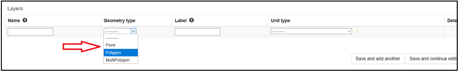
Make Layer.geometry_type a ChoiceField - DATA-280
-
This feature is about making the
Geometry type fielda ChoiceField so that user of the system can more easily select the specific geometry type.
Make is_staple_food visible through the browseable API and /en/schema-ui interfaces - DATA-292
-
This feature is about allowing the filter
is_staple_foodto become accessible through the browseable APIs’ of (https://fdw.fews.net/api/marketprice/?is_staple_food , https://fdwdev.fews.net/api/marketproduct/?is_staple_food and https://fdw.fews.net/api/marketprice/?is_staple_food=0 , https://fdw.fews.net/api/marketproduct/?is_staple_food=0)
Enhanced Geographic Unit Map View in FDE - DATA-293
-
This enhancement is about including the
Estimated Population,AreaandEstimated Population Densityfields in the tabular view of the spatial data domain and as well as adding theExporttab that shows a download button with the refreshable links for extracting the selected units either usingformat=geojsonorformat=shapefile.
Prototype: Interactive Map Visualization for COVID-19 website page - DATA-303
-
This feature is a prototype for visualizing the covid-19 statistics through the interactive maps by implementing the
Peak needsandCovid 19 cases/deathsAPI end points.
Add a country_code filter to CountryFilter - DATA-310
-
This feature allows users to filter list of countries either using the country codes as seen here: https://fdw.fews.net/api/country/?country_code=KE&country_code=TZ&country_code=UG&country_code=ET) or the full name of the countries, as seen here: https://fdw.fews.net/api/country/?country=Kenya&country=Tanzania,%20United%20Republic%20of&country=Uganda&country=Ethiopia)
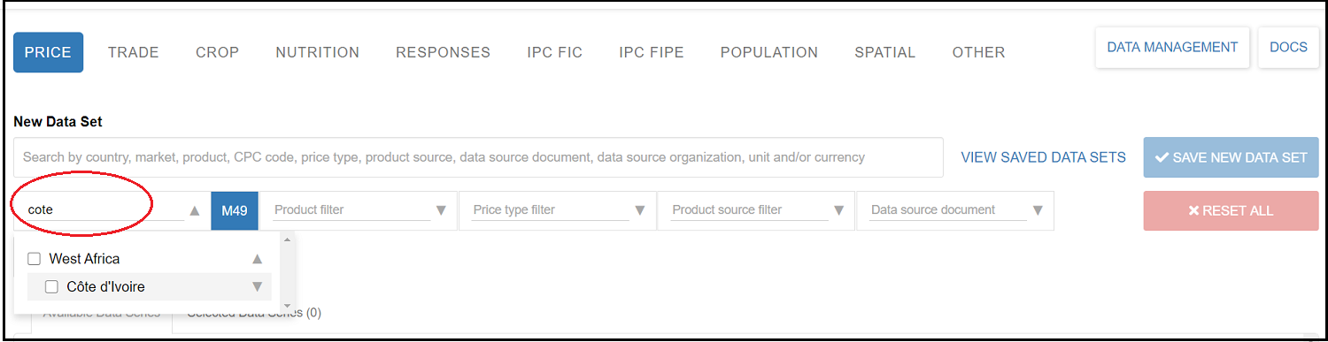
Unaccented search in FDE Geography Filter - DATA-321
-
This feature is about enhancing the search capability of the FDE i.e allowing the FDE to make search using both the accented and unaccented versions of characters.
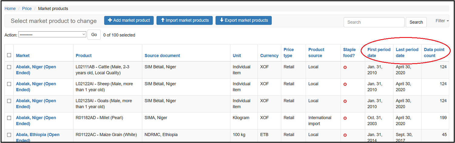
Update all DataSeries subclass Admins to show facts - DATA-327
-
This feature is about showing the facts i.e (
Firstperiod date,Last period dateandData point count) on all DataSeries subclass Admins of all the data domains.
Add caching to /api/ipcphasemap - DATA-331
-
This feature is about implementing caching for the /api/ipcphasemap endpoint which makes the response time of the queries faster.
Tasks
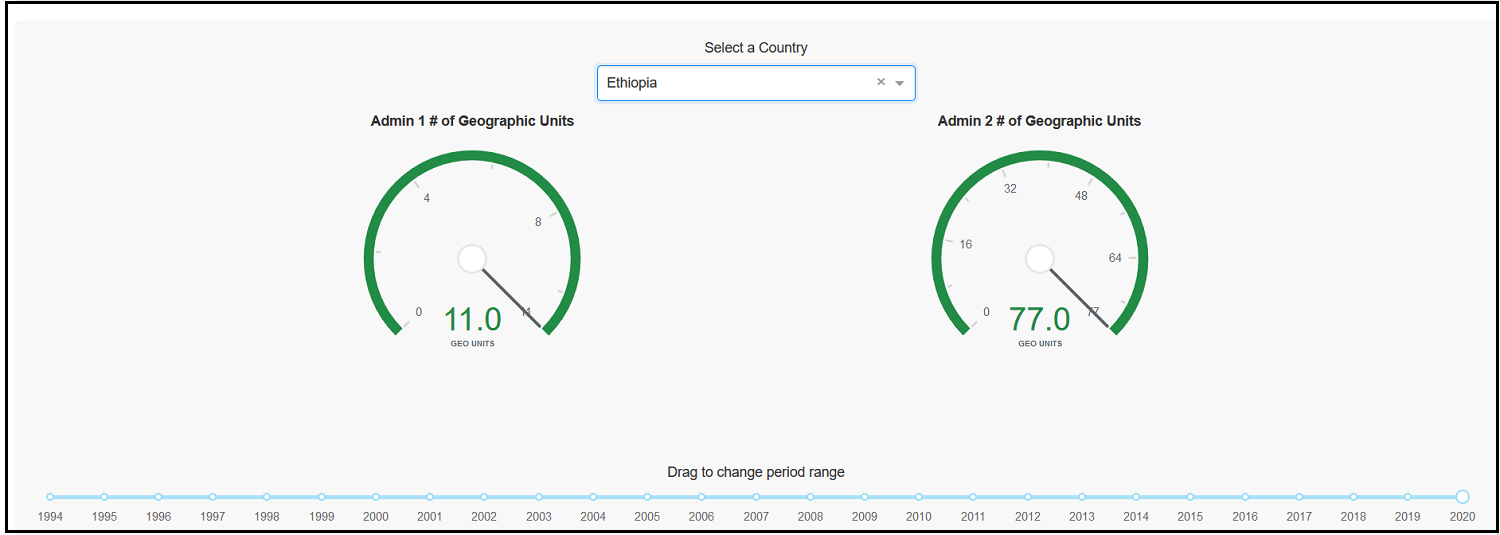
Investigate the completeness of the Geographic Unit Relationships at the Country level - DATA-268
-
This task was about investigating and showing the current Geographic Unit Relationships at the country level which helps to assess the completeness of the Geographic Unit Relationships of the different countries.
Remove Search for Crop Production Indicator and Crop Production Indicator Value - DATA-286
-
Since the current generic search box of the
Crop Production IndicatorandCrop Production Indicator Valueis slow due to the volume of the Crop production data , this task was about removing the Search box from the(https://fdw.fews.net/en/admin/survey/cropproductionindicator/) and (https://fdw.fews.net/en/admin/survey/cropproductionindicatorvalue/). This will be replaced once a better solution is in place.
Peak needs API end point - DATA-335
-
This task was about creating API end point that reads the the GoogleSheet (https://docs.google.com/spreadsheets/d/1honKsI13RIkwB-DTJg7SqVHkqPgKjOsiljzUkJSqj2s/edit#gid=0and returns the whole country’s data at (https://fdw.fews.net/api/efapeakneeds/) or if a specific country_code is passed, for instance, (https://fdw.fews.net/api/efapeakneeds/?format=api&country_code=AF) then that specific country’s data will be returned as a result.
Covid-19 cases/deaths API end point - DATA-336
-
This task was about adding the API end point https://api.covid19api.com/all which returns the whole country’s cases/death data and in addition to this if a country_code parameter is passed to the query such as https://fdw.fews.net/api/covid19/?country_code=ET then the data of this specific country will be returned as a result.
Remove the Search box from the Crop production tab of the FDE - DATA-356
-
Since the crop production data can be searched using an individual filters, this task was about removing the Search bar from the FDE of the crop data domain.
Bugs
Fix "[invalid name]" filter labels - DATA-285
-
A number of browseable API end points had an incorrect label and this was resolved.
Dataset 981 pulling wrong/unknown CPI data - DATA-289
-
The CPI data of the country Haiti had shown incorrect values and this was resolved and the dataset is now pulling the correct value.
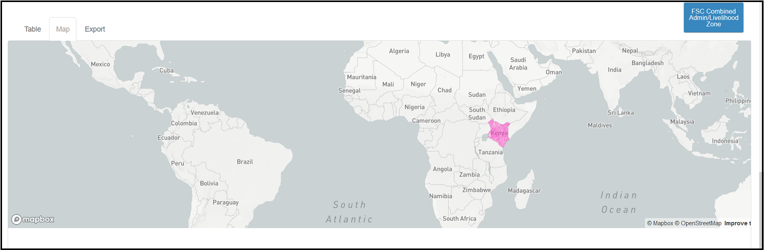
FDE Spatial map view doesn't work for Kenya FSC Units 2016 - DATA-290
-
There was an issue in not being able to view the Kenya FSC Units 2016 Spatial map and this was resolved.
Spatial view has unusual behaviour around selected Versions - DATA-291
-
There was an issue in deselecting the data series records from the list of the
Available Geo unit set versionspage and this was resolved and the functionality is working as expected.
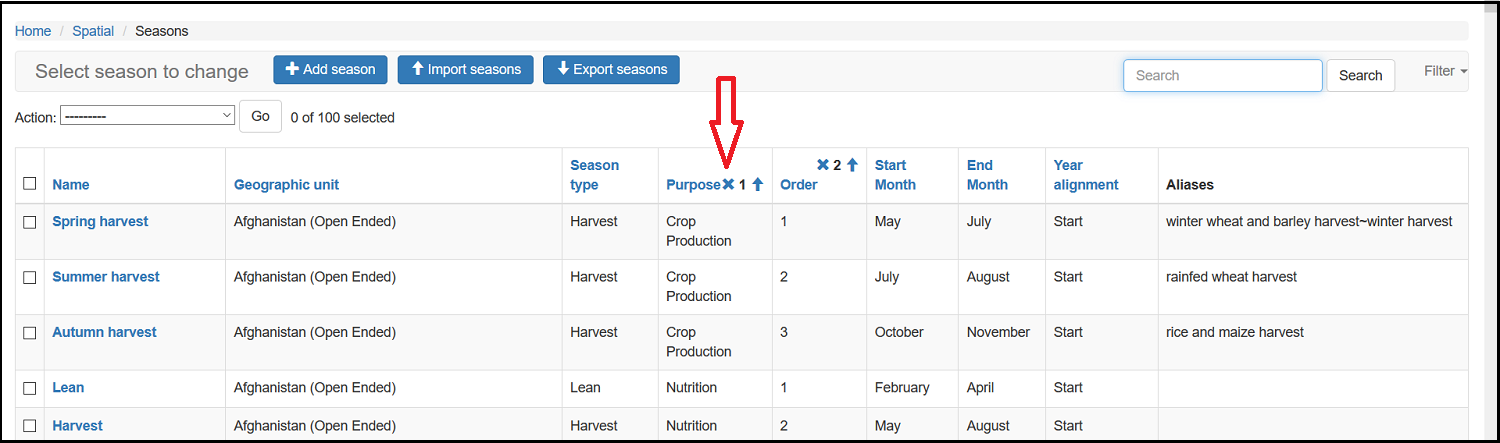
All the season records of the Crop Production data domain do not show the specific data domain i.e (Crop Production) - DATA-297
-
The season records of the crop production data domain was missing the column with information of the specific data domain name and this was resolved and all the season records shows the specific data domain type.
Unable to access Geographical Unit Set Versions that contain Markets via the API - DATA-300
-
It was the
no resulterror message that was displayed upon trying to access the API of the Geographic Unit Set Versions that contains markets, as seen here: https://fdw.fews.net/api/geographicunitsetversion/365. This was resolved and the Geographical Unit Set versions that contain Markets can now be accessible through the API.
500 error on /api/geographicunit/ with both unit_type and used_for parameters - DATA-322
-
Tying to access an API (/api/geographicunit/) with a combination of the parameters
unit_typeandused_for, for instance, https://fdw.fews.net/api/geographicunit/?unit_type=admin3&used_for=CropProductionIndicator, was showing a ‘500 Internal Server error’ and this was resolved and the API is now accessible.
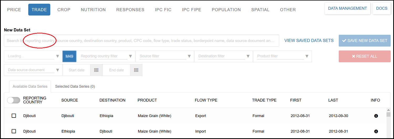
Placeholder text on Trade domain search bar says "report country" instead of "reporting country" - DATA-323
-
The placeholder text for the Trade data domain search bar was displayed as
report countryand now it’s renamed to the correct sayingreporting country.
Accessing the https://fdw.fews.net/dashboard/inventory/ with out a superuser right results in 403 Forbidden page - DATA-328
-
The system was showing the ‘403 Forbidden’ page when accessing the https://fdw.fews.net/dashboard/inventory/ without a superuser right, and this was resolved. The
Inventory Dashboardis now accessible without a superuser right access.
Incorrect FDW calculations (Forex) - DATA-329
-
There was an incorrect calculated field of the
inverse_valuewhich was shown in the data extract and this was resolved.
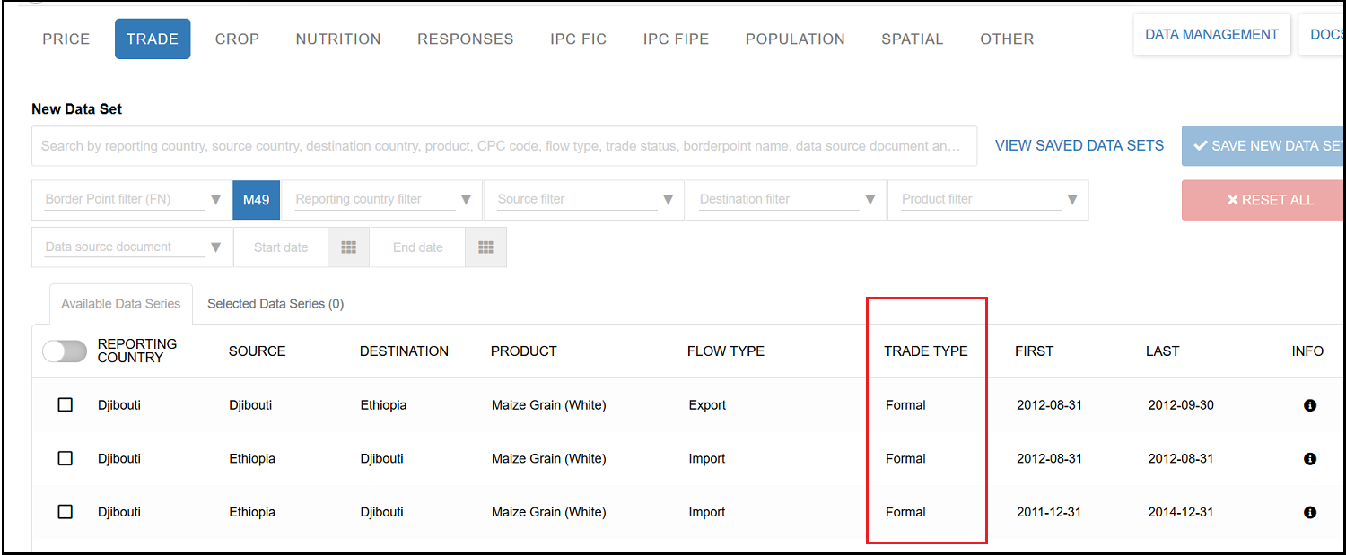
The UI Screen of the Trade data domain of the FDE does not show data for the Trade status / Trade type column information - DATA-334
-
The UI Screen of the Trade data domain of the FDE did not show the data for the Trade status / Trade type column information and this was resolved.
Unable to save Livelihood Zones when a Geographic Unit Version is saved - DATA-337
-
When a Geographic Unit Set Version was saved with a Livelihood zone data of the shape file, the corresponding values of the Livelihood Zone data did not saved and this was resolved. The list of the livelihood zones data are shown (i.e https://fdw.fews.net/en/admin/spatial/livelihoodzone/?q=kenya) after saving the Geographic unit set version of the livelihood zone shapefile data (i.e. https://fdw.fews.net/en/admin/spatial/geographicunitsetversion/1350/change/).