Last update: December 2025
This page contains information about some of the data available in the FEWS NET Data Explorer (FDE) for Malaysia. This is not a comprehensive guide.
For information about using the filters and fields for specific topics in the FDE, see Explore Data.
Summary table
|
ISO 3166-1 codes |
Alpha 2: MY, Alpha 3: MYS, Numeric: 458 |
|---|---|
|
Administrative units |
State/territory, division/district, district/mukim |
|
Agricultural seasons |
Annual, main, off-season |
|
Major crops |
Rice, pineapple, coconut, mixed vegetables, mixed fruits, cash crops, cocoa, tea |
Acknowledgements
The Malaysian crop dataset found in the FEWS NET Data Warehouse, and this Country Book publication are a joint effort of the United States Department of State-funded Famine Early Warning Systems Network (FEWS NET), the Harvard University School of Earth and Planetary Sciences (URL), and HarvestStat Asia (URL). HarvestStat Asia provides a database of subnational crop data for 20 countries across Southeast Asia in formats that are interoperable with the FEWS NET Data Warehouse, and ready for machine-learning. For additional information, please refer to the HarvestStat Asia data publication (URL) and the FEWS NET Data Explorer Knowledge Base.
Country food security context
Agriculture, fishery and forestry sectors of Malaysia comprise 10% of the labor force and represent roughly 10% of GDP (http://trade.gov reports 8% while Wikipedia reports 12%). Primary outputs are palm oil, rubber, cocoa, and wood, while rice and tropical fruits represent other contributors in food.[1] Malaysian palm oil is a key industry and we include production information where available in our dataset, as it represents 26% of world production. The Ministry of Agriculture generally focuses on improvements in agriculture in this sector for that reason. Rice production is subsidized by the Government of Malaysia Plantations were established during colonial rule and large areas remain dedicated to food production throughout Malaysia.
Just under 25% of land is dedicated to agriculture with 7.6 million hectares of arable/permanent cropland.[2] There has been a decrease in rubber production since 2009 as the country has shifted focus onto palm oil production, but before 2009 the country represented a third of global exports of rubber and has now fallen to a sixth of these exports, controlling 46% of global rubber production.
FEWS NET’s use of Wikipedia
While Wikipedia may not be appropriate for all research contexts, it serves as a valuable and often irreplaceable source for certain types of information. For rapidly changing data where timeliness is critical, Wikipedia's strengths often outweigh the limitations typically associated with user-generated content, as is the case here.
Statistical reporting units
Malaysia usually uses administrative units as their statistical reporting units. There are three levels in the administrative hierarchy, though Malaysia is informally often divided into what we might call a 0.5 level of administrative division:
-
Peninsular Malaysia
-
East Malaysia with its two Borneo states of Sabah and Sarawak
-
The offshore financial centre territory of Labuan
Administrative (admin) units are the geographical areas into which a country is divided. FEWS NET uses the following terminology: National boundary = admin 0, First sub-national division = admin 1 (e.g., states in the United States), Second sub-national division = admin 2 (e.g., counties in the United States), and so on.
The Federal Government of Malaysia is based in Putrajaya, a federal territory, and its legislative branch is based in Kuala Lumpur. The 11 states of Malaya (peninsular Malaysia), Borneo states of Sabah and Sarawak, and 3 federal territories are united under a constitutional monarchy. The states themselves have administrative bodies that have their own leadership. Local governments below the state level conduct tax assessments and create by-laws and deal with local area planning and civil services. There are 155 local authorities below the state/territory level that depend on the structure and geography of the larger states and territories.
Malaysia has three formal levels of the country’s administrative hierarchy.
Admin 1: States (negeri) and federal territories (wilayah persekutuan). There are 11 states and 2 federal territories of Malaysia. The states are Johor, Kedah, Kelantan, Malacca, Negeri Sembilan, Pahang, Penang, Perak, Perlis, Selangor (which has two federal territories as described above), and Teregganu. East Malaysia has two states of Sabah and Sarawak – Sabah has land borders with Indonesia and Sarawak and boasts significant coastlines, and Sarawak is the largest of the states and shares international borders with Brunei and Indonesia. The territory of Labuan is also in the East Malaysia region of Malaysia.
There have been largely no changes to Malaysia’s Admin 1 designations over the covered time period. The territory of Labuan was ceded from Sabah in 1984, and it became an international offshore financial center in 1990. Kuala Lumpur became a territory in 1974, and Putajaya was officially established as a federal territory in 2001. Other than the designation of these territories, boundaries of Admin 1 level units are largely stable.
Admin 2: Districts (daerah) and divisions (bahagian). Malaysia’s second-level administrative divisions are divisions of the states and territories, except for the states of Sabah and Sarawak, where these districts are grouped as divisions. District governments attend to many land matters and work with land revenue rather than dealing with municipal administration or infrastructure which falls to the larger administrative divisions. Some districts have smaller divisions of sub-districts before the mukim level. Sabah and Sarawak do not have the mukim level, only subdistricts. Perlis, being a small state, has no districts but rather has only the mukim or a sub-district level. The three federal territories also do not have districts but Kuala Lumpur is divided into mukim and Putrajaya into precincts for local governance.
Admin 3: Sub-district/commune (mukim) and villages. Below the district level, the peninsular states are divided into sub-districts (mukim). The smallest units of governance in Malaysia are the villages led by village leaders, largely unofficial designations.
Crop data
Explore our crop data.
Crop estimate data sources
Malaysian crop statistics are primarily derived from Perangkaan Agromakanan, an annual publication of government-reported crop statistics prepared by the Malaysia Ministry of Agriculture and Agro-based Industry. Our data derives from the 2011, 2015, 2019, and 2023 statistical reports as well as several archival reports compiled by the government on crop-specific data that were published earlier and extend this timeline.
The government disseminates state and district-level crop statistics for the 2017 to present period at Malaysia’s official open data portal. The district data only includes area planted (no production variable).
Additional crop statistics and information are available in the Malaysia Statistical Handbook (Buku Maklumat Perangkaan), published by the Department of Statistics.
Crop reporting units
Malaysian agricultural statistics most often either report at the state/territory level or at a broader level where the only distinctions are Peninsular Malaysia (Malaya), and the two Borneo states of Sabah and Sarawak. The focus of the crop statistics found in the FEWS NET Data Warehouse (FDW) and HarvestStat Asia is the Admin 1-level.
Year and season definition
There tends to be a main and secondary crop harvest for paddy rice and the main tropical fruit season is June-August with the off season being December-February. Paddy rice statistics for a reference year will include data for main season crops in the previous year in addition to main season and off-season crops for that year.
Example: 2011 paddy rice data will include data for main season crops in 2010/2011 and off-season crops in 2011.
Some FEWS NET data also reports Off Season and Main Season values, especially for paddy rice. These statistics are available for a limited number of data at the zone level and may impose a higher level of rounding on their data.
The climate conditions within Malaysia are typical of tropical peninsular environments – it is rarely afflicted by droughts and hurricanes, generally experiences heavy rainfall, and has a humidity level at 90% because of its geographical location. The weather remains warm throughout the year, with temperatures of 21-32 C daily, allowing for continual crop production. The day maintains a length around 12.5 hours throughout the year. Recently, in addition to concerns related to temperature change, droughts and floods threaten to change food security and impact rice especially aggressively.[3]
FAO describes peninsular Malaysia in several agro-ecological regions – highland, regions with a regular dry season and without, and regions where Histosols predominate. While the soil is dominantly orthic acrisoles, there is some regional variation in soil type closest to the coastlines that impact effective agriculture strategies.
East Malaysia has organic plains, clay plains, river zones, mountainous regions, and freshwater areas in comparison. Because the soil is predominantly Ultisols and Oxisols that are highly weathered and acidic, phosphate fertilizers are not always effective and limestone gets added biennially at 2-4 tons/hectare.[4]
Rice seasonality varies slightly based on peninsular vs East Malaysia geographical regions.
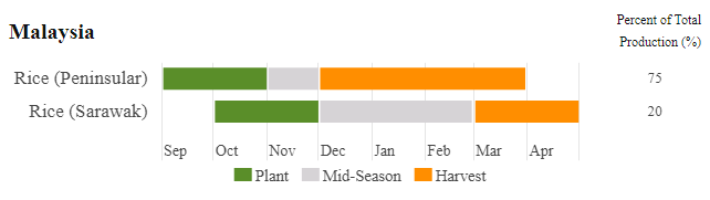
Rice in Sarawak is planted October and November and harvested in March and April.
Primary crops
The principal food crops grown in the country are rice, pineapple, and coconut, as well as many other fruits, vegetables, and cash crops, each reported in aggregate.
|
Crop (Malay) |
Crop (EN) |
Code |
|---|---|---|
|
Minyak kelapa sawit |
Palm oil |
R01491AA |
|
Getah |
Rubber |
R01950AA |
|
Koko |
Cocoa |
R01640AA |
|
Beras (padi) |
Rice (paddy) |
R01132AA |
|
Buah nanas |
Pineapple |
R01318AA |
|
Kelapa |
Coconut |
R01460AA |
|
Teh |
Tea |
R01620AA |
|
Sayuran utama |
Major vegetables |
R01290AA |
|
Buah-buahan utama |
Major fruits |
R01319AA |
|
Tanaman kontan utama |
Major cash crops |
NA |
Production systems
No production system break-outs (e.g. irrigated or rainfed, commercial, small-farm, etc.) are provided in the source data, except in certain small cases. FEWS NET off season paddy rice production, for example, uses a wetland production method. Only about 5% of cropland is actually irrigated in Malaysia.[5]
Crop statistics context
The country’s available crop data are primarily concentrated in the period between 2006-2022.
Crop yields have been independently calculated based on the available information. Crop area may be provided either in acres or in hectares. Production quantities are generally given in metric tons.
Methodology
No current information is available for the method the Malaysia Ministry of Agriculture and Agro-based Industry uses to make annual crop estimates.
[1] https://www.trade.gov/country-commercial-guides/malaysia-agricultural-sector
[2] https://en.wikipedia.org/wiki/Agriculture_in_Malaysia
[3] https://en.wikipedia.org/wiki/Agriculture_in_Malaysia