Last update: March 2026
This page contains information about some of the data available in the FEWS NET Data Explorer (FDE) for Indonesia. This is not a comprehensive guide.
For information about using the filters and fields for specific topics in the FDE, see Explore Data.
Summary table
|
ISO 3166-1 codes |
Alpha 2: ID, Alpha 3: IDN, Numeric: 360 |
|---|---|
|
Administrative units |
Province; Regency/City; District; Village |
|
Agricultural seasons |
Main rainy season, dry season |
|
Major crops |
Rice, maize, soybean, palm oil |
Acknowledgements
The Indonesian crop dataset found in the FEWS NET Data Warehouse, and this Country Book publication are a joint effort of the United States Department of State-funded Famine Early Warning Systems Network (FEWS NET), the International Food Policy Research Institute (IFPRI), and the Harvard University School of Earth and Planetary Sciences via HarvestStat Asia. HarvestStat Asia provides a dataset of subnational crop data for 20 countries across Southeast Asia in formats that are interoperable with the data in the FEWS Data Warehouse and ready for academic analysis. For additional information, please refer to the HarvestStat vision paper, the HarvestStat website and the FEWS Data Explorer Knowledge Base.
Country food security context
Statistical reporting units
Indonesia usually uses administrative units as their statistical reporting units. Article 18 paragraph 1 of the 1945 Constitution states that "the Unitary State of the Republic of Indonesia is divided into provincial regions and those provincial regions are divided into regencies and city, whereby every one of those provinces, regencies, and municipalities has its regional government, which shall be regulated by laws."
Administrative (admin) units are the geographical areas into which a country is divided. FEWS NET uses the following terminology: National boundary = admin 0, First sub-national division = admin 1 (e.g., states in the United States), Second sub-national division = admin 2 (e.g., counties in the United States), and so on.
Admin 1: There are 38 provinces at the first-level of administrative divisions of Indonesia. Before 1998, they were called first-level provincial regions (provinsi daerah tingkat I). Nine of the provinces have special autonomy, the form of which is not standardized. These provinces have gained different formulations of specific autonomy based on particular political imperatives.
-
Jakarta Special Region: Jakarta is the largest city of Indonesia, and as a Special Region it has a provincial-level of autonomy to manage its own affairs.
-
Aceh: Aceh has greater role in local government, which includes its own Islamic Sharia law (for Muslim citizens), flag, and provincial anthem. Local political parties are allowed, and decisions or laws made by the central government which directly affect Aceh's administration must be referred to the local government or legislative body.
-
Yogyakarta Special Region: The Sultan of Yogyakarta is de facto and de jure governor of Yogyakarta. Since August 31, 2012, Law Number 13 of 2012 on Specialty of Yogyakarta Special Region has been approved by the central government and according to the act, Yogyakarta is a region at province-level.
-
Papua: Granted Special Autonomy to achieve justice, accelerate development, improve welfare, and protect the rights of Indigenous People.
-
West Papua: The province of West Papua was established out of the western portion of the province of Papua in February 2003, initially under the name of West Irian Jaya (Irian Jaya Barat). A 2008 regulation by the national government confirms that special autonomy status in Papua also applies to West Papua.
-
Central Papua: Split from Papua in 2022.
-
Highland Papua: Split from Papua in 2022. This province is the only landlocked province in Indonesia.
-
South Papua: Split from Papua in 2022.
-
Southwest Papua: Split from West Papua in 2022.
Admin 2: At the second-level of administration are found regencies (kabupaten) and cities (kota), formerly called second-level regencies and cities (kabupaten/kotamadya daerah tingkat II).
Admin 3: The third-level of administration are districts. Districts are divided into fourth-level villages (desa) and urban communities (kelurahan).
Island groupings: Although there is no administrative function allocated to any of Indonesia’s more than 17,000 islands, or to the best known of its island groupings (e.g. Java, Sumatra, Lesser Sunda), statistics are often grouped by these geographic regions. The best known among these include:
-
Bali
-
Borneo
-
Flores
-
Java
-
Lesser Sunda Islands
-
Lombok
-
Maluku Islands
-
New Guinea/Papua
-
Sulawesi
-
Sumatra
-
Sumba
-
Sumbawa
-
Timor
Evolution of Administrative Units
Following the fall of the Suharto government, a decentralization policy was enacted in 1999 which encouraged efforts to split existing provinces to be more responsive to local desires for some form of autonomy. The number of provinces increased from 27 to 38, with new provinces in Sumatra and Papua constituting the largest number. In 2002, East Timor became independent of Indonesia. A moratorium on the creation of new regions put in place in 2013 was only breached by the 2022 split of Papua into several new provinces.
Crop data
Explore our crop data.
Statistical data at the district, regency, and provincial levels are often not synchronized or integrated because agencies at each level collect their own data independently. In districts, regencies, and provinces where development has been slower, less data may be available, while provinces with faster development may have longer time-series.
For long-term analyses, it may be necessary to group the data into periods such as pre-1990, 1990–2000, and post-2000, since data collection methods and availability may differ across these periods. For example, in 2003–2005, some regency-level data are recorded as 0, which may reflect decisions by regency level officials not to collect the data, given that provincial-level data would be collected.
Data reliability and completeness also depend on the commodity being analyzed. For rice, maize, and soybeans (major food staples), shallots, curly red chilies, and cayenne (horticultural commodities associated with inflation), as well as palm oil and rubber (major export plantation commodities), the data are probably better. The government tends to prioritize data availability for certain commodities based on its development focus at the time, while other commodities receive less attention. Provincial-level data are generally more feasible for statistical analysis. Regency- and district-level data may be more diverse and less consistent in availability and collection methods, but they may still be useful to support analyses.
Crop estimate data sources
There are two key sources of Indonesian crop statistics. One is an on-line database of agricultural commodity data hosted by the Data Center and Information System of the Ministry of Agriculture (Kementerian Pertanian).
The other is an archive of current and older statistical reports/publications managed by the national statistics agency, Badan Pusat Statistik, which provides both data tables and publications.
Additional regency and district-level crop statistics publications may sometimes be available from the national statistics agency, BPS. They are currently found by specifying a regency name in the “select region” box of the BPS search engine.
Crop reporting units
In Indonesia, most crop statistics are presented at the first-level (Admin 1) of administrative units. Some provinces and regencies make lower-level data available through statistical yearbooks (see Crop Estimate Data Sources).
Year and season definition
Cropping Year definition
The annual cropping year cycle generally begins with planting at the onset of the main rainy season in November and ends in October of the next year. Indonesia’s annual crop statistics nevertheless refer to harvests that occur in the January to December period. The harvest year is therefore almost always given with a single-year designation.
Example: 2024 reflects harvests occurring between January and December 2024.
Seasonal definitions
Indonesia has two main seasons:
-
Rainy (or wet) season: November to March; characterized by heavy rainfall that often occurs in short, intense bursts.
-
Dry season: generally April to October; features less rain and lower humidity.
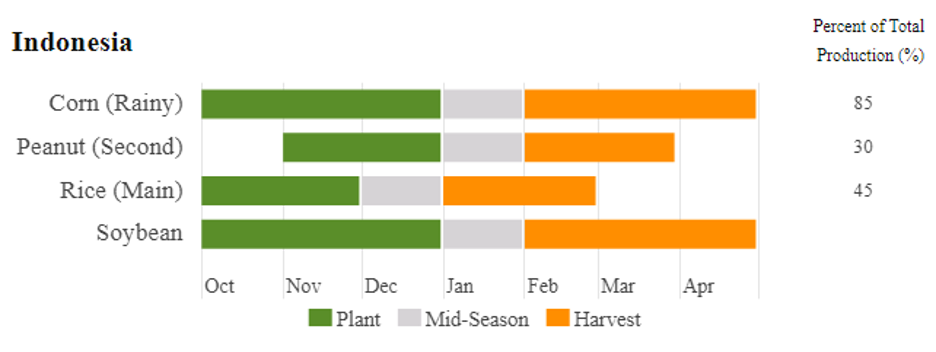
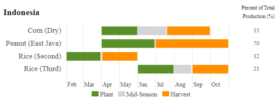
This pattern allows Indonesia to typically experience three growing seasons per year for major crops like rice and maize, allowing for two lowland rice crops and one upland crop (palawija) like maize, soybean, etc.
-
The rainy season crop for rice is planted in November–December and harvested in January–February.
-
A dry season crop is planted in February–March and harvested in May–June.
-
The third crop, often a palawija like maize, is planted in June–July and harvested in August–September.
Crop Calendar
The Foreign Agriculture Service of USDA makes available crop calendars for major cropping seasons worldwide. Here we reproduce crop calendars for the major crops in the wet and dry seasons.
Primary crops
Indonesian Crop Names and Codes
|
Crop Name (ID) |
Crop Name (EN) |
Botanic name |
|
|---|---|---|---|
|
R01122AA |
Jagung |
Maize |
Zea mays |
|
R01132AA |
Padi |
Rice, paddy |
Oryza sativa |
|
R01132AA |
Padi ladang |
Rice, paddy, dryland |
Oryza sativa |
|
R01132AA |
Padi sawah |
Rice, paddy, wetland |
Oryza sativa |
|
R01212AA |
Kubis |
Cabbage |
Brassica oleracea capitata |
|
R01212AE |
Petsai |
Chinese Cabbage |
Brassica rapa pekinensis |
|
R01212AE |
Sawi |
Chinese Cabbage |
Brassica rapa pekinensis |
|
R01213AA |
Kembang Kol |
Cauliflower |
Brassica oleracea botrytis |
|
R01215AA |
Bayam |
Spinach |
Spinacia oleracea |
|
R01219AN |
Kangkong |
Kangkong |
Ipomoea aquatica |
|
R01221AA |
Semangka |
Watermelon |
Citrullus lanatus |
|
R01229AA |
Melon |
Melon |
Cucurbitaceae |
|
R01229AB |
Blewah |
Canteloupe |
Cucumis melo |
|
R01232AA |
Ketimun |
Cucumber |
Cucumis sativus |
|
R01233AA |
Terung |
Eggplant |
Solanum melongena |
|
R01234AA |
Tomat |
Tomato |
Solanum lycopersicum |
|
R01235AA |
Labu Siam |
Chayote |
Sechium edule |
|
R01241AA |
Buncis |
Green bean |
Phaseolus vulgaris |
|
R01251AA |
Wortel |
Carrot |
Daucus carota |
|
R01252AB |
Bawang Putih |
Garlic |
Allium sativum |
|
R01253AC |
Bawang Merah |
Shallots |
Allium cepa |
|
R01253Ae |
Bawang Daun |
Welsh Onion |
Allium fistulosum |
|
R01259AC |
Lobak |
Radish |
Raphanus sativus |
|
R01270AA |
Persegi Jamur |
Mushroom |
Agaricus bisporus |
|
R01290AA |
Sayuran |
Vegetables |
vegetables (uspecified) |
|
R01310XX |
Buah-Buahan |
Fruit |
fruits (unspecified) |
|
R01312AA |
Pisang |
Banana |
Musa acuminata |
|
R01316AA |
Mangga |
Mango |
Mangifera indica |
|
R01319AH |
Durian |
Durian |
Durio zibethinus |
|
R01319AN |
Manggis |
Mangosteen |
Garcinia mangostana |
|
R01321AB |
Jeruk Besar |
Pomelo |
Citrus maxima |
|
R01329AA |
Jeruk Siam |
Citrus |
Citrus (unspecified) |
|
R01344AA |
Stroberi |
Strawberry |
Fragaria x ananassa |
|
R01372AA |
Jambu Mete |
Cashewnut |
Castanea |
|
R01412AA |
Kedelai |
Soybean |
Glycine max |
|
R01422AA |
Kacang tanah |
Groundnut |
Arachis hypogaea |
|
R01449AK |
Kemiri Sunan |
Philippine tung |
Aleurites trisperma |
|
R01460AA |
Kelapa |
Coconut |
Cocos nucifera |
|
R01491AA |
Kelapa Sawit |
Oil Palm oil |
Arecaceae |
|
R01510AA |
Kentang |
Potato |
Solanum tuberosum |
|
R01591AA |
Ubi Jalar |
Sweet potato |
Ipomoea batatas |
|
R01592AA |
Ubi Kayu |
Cassava |
Manihot esculenta |
|
R01596AC |
Sagu |
Sago |
Metroxylon sagu |
|
R01610AA |
Kopi |
Coffee |
Coffea |
|
R01620AA |
Teh |
Tea leaves |
Camellia sinensis |
|
R01640AA |
Kakao |
Cacao |
Theobroma cacao |
|
R01651AA |
Lada |
Pepper |
Piper nigrum |
|
R01652AF |
Cabai Rawit |
Cayenne |
Capsicum frutescens |
|
R01652AF |
Cabai Rawit |
Small chili |
Capsicum frutescens |
|
R01652AI |
Paprika |
Sweet pepper |
Capsicum annuum |
|
R01652AL |
Cabai Besar |
Hot red chili |
Capsicum annuum |
|
R01653AA |
Pala |
Nutmeg |
Myristica fragrans |
|
R01654AY |
Kunyit |
Turmeric |
Curcuma longa |
|
R01654BC |
Nilam |
Patchouli |
Pogostemon cablin |
|
R01656AA |
Cengkeh |
Clove |
Syzygium aromaticum |
|
R01657AA |
Jahe |
Ginger |
Zingiber officinale |
|
R01657AC |
Kencur |
Greater Galingale |
Kaempferia galanga |
|
R01657AC |
Lengkuas |
Galingale |
Alpinia galanga |
|
R01657AE |
Lempuyang |
Lempuyang |
Zingiber amoricans |
|
R01701AG |
Kacang Merah |
Red Bean |
Phaseolus vulgaris |
|
R01706AB |
Kacang Panjang |
Yard Long Bean |
Vigna unguiculata sesquipedali |
|
R01708AA |
Kacang Hijau |
Mung bean |
Vigna radiata |
|
R01802AA |
Tebu |
Sugar cane |
Saccharum officinarum |
|
R01921AA |
Kapas |
Cotton |
Gossypium |
|
R01950AA |
Karet |
Rubber |
Hevea brasiliensis |
|
R01970AA |
Tembakau |
Tobacco (unspecified) |
Nicotiana tabacum |
Production systems
The farming systems practiced by Indonesian farmers can be classified into three major systems: lowland, upland and perennial crop farming systems.
The lowland farming system, with rice as the single crop, provides the staple food for the ever-growing population of Indonesia, a population that in early 2000 amounted to more that 200 million people. Lowland farming is a source of food, wealth and job opportunities for most of the Indonesian people living in rural areas. Irrigated lowland rice is the most appropriate system in terms of sustainability and year-to-year yield stability. High rates of fertilizer use and improved crop protection practices have contributed to the high yields of rice.
In recent years, rice farming has become less attractive due to these factors:
-
Land conversion: Rice area in Indonesia has gradually declined, directly contributing to lower production.
-
Climate change and natural disasters: Disasters such as floods and droughts (including El Niño) are occurring more frequently, reducing yields.
-
Farmer regeneration: Younger generations are reluctant to farm, so the farming population is aging, which poses a threat to food security.
-
Technology and farm scale: Smallholders (petani gurem) dominate with increasingly small landholdings, and limited adoption of modern technology leads to suboptimal land use.
Upland farming is practiced mostly under rainfed conditions in the outer islands. Upland soils are dominated by highly weathered acid soils, Ultisols, Oxisols and Inceptisols, whose phosphorus deficiency is usually a major constraint to crop production. Upland areas are abundant in the country and have a high potential for agricultural development. To date these resources have been underutilized and their productivity remains low, partly due to inadequate fertilizer application. The low level of fertilizer use for upland farming is resulting in the depletion of soil nutrients in the upland crop areas (Santoso, 1996).
Perennial farming systems, practiced mostly in the outer islands, are sustainable under the inherently acid soils of low fertility in these areas. Rubber and oil-palm are the two major perennial crops, produced both in large estates and by smallholders. The large plantations are both government and privately owned. Because of the favourable income obtained from oil-palm, the area planted with oil-palm has increased significantly during the past ten to fifteen years and the total harvested area has reached more than four million hectares. Large areas of plantation crops are owned and managed by smallholder farmers. Unfortunately, due to a lack of knowledge of appropriate fertilization technology and the fact that fertilizers are sometimes not available at village level on time and of the right type, the use of fertilizers is inadequate and unbalanced in many plantations. If these farmers use fertilizers, they normally apply low, unbalanced rates, mostly just urea, and only for the food crops.
In addition to the above systems, a traditional shifting cultivation, the slash and burn system, is still practiced by some farmers, particularly in the remote areas on the islands outside Java. The system is characterized by the felling of old rubber trees or secondary forest, followed by burning and then planting new rubber trees mixed with food crops, generally upland rice and maize, for subsistence purposes. After two to three years of cultivation, when the rubber trees have started to cover the ground and the productivity of the food crops begins to decline, the shifting cultivators move to another area of land, waiting until the rubber trees are ready to be tapped. Under this system, the use of fertilizers is uncommon.
Crop statistics context
Principal Crop Variables
The main food crops data collected consists of harvested area and productivity (yield per hectare). Food crops production is generated by multiplying harvested area and productivity.
Crop types
Food crops, horticulture, and estate crops) are the focus of FDW crop statistics holdings.
-
Food crops (tanaman pangan) include paddy rice, maize, mung bean, peanut/groundnut, soybean, cassava, and sweet potato.
-
Horticultural crops (tanaman hortikultura) include both vegetables and fruits.
-
Vegetables: leeks, shallot, garlic, spinach, green bean, chili, cayenne pepper, red bean, long bean, kangkoong, potato, cucumber, cabbage, turnip, melinjo, twisted cluster beans, petsai, eggplant, tomato, and carrot.
-
Fruits: avocado, apel, starfruit, duku, durian, guava, orange, mango, melon, jackfruit, pineapple, papaya, banana, rambutan, salacca, sapodila, watermelon, soursop.
-
-
Estate crops (tanaman perkebunan) primarily include major global commodities, mostly for export: rubber, coconut, oil palm, coffee, tea, sugar cane, clove, and tobacco.
Symbols used in crop statistic presentations
These symbols are not consistently applied between food, horticultural and estate crops in all presentations:
-
“...” = data not available
-
“NA” = data not available
-
“–“ = null, none or zero
-
“r” = corrected numbers
-
“0” = data are negligible, less than 1 hectare or 1 quintal
-
“*” = temporary figures
-
“**” = very provisional figures
-
“***” = very very provisional figures
Methodology
The harvested area data is collected monthly by the Agriculture Extension Workers (called KCD for Kepala Cabang Dinas) and reported in an Agriculture Statistics Form called “SP” for Statistik Pertanian). Data collection is conducted in all sub-districts in Indonesia.
Harvested area in each sub district is estimated based on the harvested area in each village in the sub district. Food crops productivity (yield per hectare) data are collected through the Crop Cutting Survey using a “SUB-S” form based on household approach. The data collection is conducted in every subround (four-monthly period) with the Sub-District Statistics Coordinator (called KSK for Koordinator Statistik Kecamatan) and the KCD being the enumerator.
The productivity data collection is conducted by a direct measurement in 21⁄2m x 21⁄2m crop cutting plot. The productivity measurement is conducted at the time when farmers are harvesting their crops.
Wetland area data is collected annually by KCD using the form called SP-Lahan. Wetland area data reported is the condition at the end of the year, and covers wetland in subdistricts administrative area, including the land cultivated by households, firms, governments, and others.
The production of paddy covers the production of wetland paddy and dryland paddy. Production of paddy and secondary crops data are presented in the form of: dry unhusked rice (paddy), dry loose maize (maize), dry shells crops (soybeans and peanuts), and fresh roots (cassava and sweet potatoes).
Plants that are harvested several times/undemolished are plants usually harvested more than once and demolished in the case that the last harvest was economically not profitable. They consist of: yarld long beans, chili, small chili, mushroom, tomatoes, eggplant, green beans, cucumber, chayote, kangkong, spinach, melon, watermelon, and cantalaupe.
From 2018 Statistical Yearbook, Indonesia