The Spatial Domain
The Spatial domain provides geographic and administrative boundary information including shapefiles, population estimates, and demography estimates including age and gender breakdowns.
The Spatial domain contains vector type data meaning that geographic unit set versions are used instead of data series.
The Spatial domain is broken into three sections:
1. Search and Filter
You can search the available Geo unit set versions using one or more of the following criteria:
Geographic unit set name: The name of any geographic unit set which is a set of geographic units that represent a specific hierarchy, for example the official government administrative hierarchy for a country.
Country: Country name or ISO 3166 code.
Learn more about search functionality in FDE.
You can filter the available Geo unit set versions using one or more of the following criteria:
Country: Filters by country.
Unit Type: Filters by type of geographic unit which is a geographic area or point such as a portion of a country or other region delineated for a specific purpose. Options include:
Admin: Official government administrative units such as Province, District, County, etc.
FSC Units: Food Security Classification units used in Food Insecurity Classification analysis. These include Livelihood Zones and other unit that may or may not be the same as Admin units.
Other Units: This category includes all other unit types such as border points, markets, IDP camps, and crop production reporting regions.
Results Valid on Date: Filters all geographic unit set versions valid on the selected date. This includes all versions with a start date on or before the selected date, and either no version end date or an end date that is on or after the selected date.
Searching and/or applying filters creates a savable dataset. For more information on creating and saving datasets, see Create and Save Datasets.
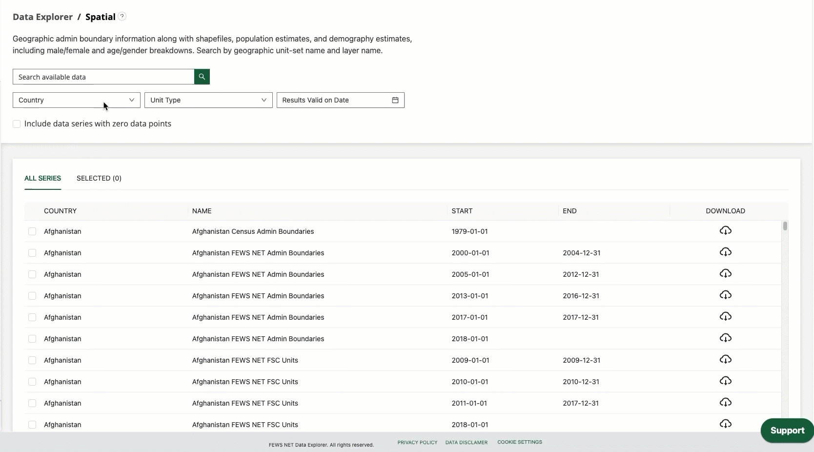
2. Data Selection
Once you have applied your search terms and filters, you will be presented with a list of all available geographic unit set versions that match your criteria.
The Spatial domain data selection table includes the following columns:
Country: The country of the geographic unit set.
Name: The name of the geographic unit set.
Start: The first date that this unit set version is used.
End: The last date that this unit set version was used.
Download: Allows you to download that geographic unit set version.
To visualize and export data, you will need to select one or more data series by checking the box at the beginning of the row containing that series.
In addition to selecting data series, you can interact with the data selection table in the following ways:
Selected data series can be viewed in the Selected tab.
You can clear your selections using the Clear Selection button.
By default the series are ordered alphabetically by country. You can click on the header of any column to sort by that column instead of by country.
3. Data Visualization and Export
Notification for selections without spatial data
If one or more of the geographic units you’ve selected do not contain spatial data, a notification will appear in this section saying, “The data series you’ve selected do not contain spatial data.” This makes it clear when geographic units cannot be visualized on the map or customized before download. Selections without spatial data can be browsed in the table view before downloading them.
Use the Table tab to explore data series with no spatial data.
Visualize
The Spatial domain includes Map and Table visualizations.
The Maps tab for the Spatial domain helps to visualize the geographic position and boundary lines of the selected Geo unit set version. The Map tab is also helpful for comparing various administrative levels and layers visually.
You can interact with the map in the following ways:
Zoom in and out using your mouse or the zoom buttons.
Click on items in the legend to include or exclude them from the map view.
Metadata
The Metadata tab provides information about the sources of selected data. The source for geographic information will always be listed. If population or demography exports are being included, this tab will also display sources for this information.
Customize
Customization options within the Spatial domain allows for aggregation or conversion of the data. The available parameters are:
Population data:
Geographic information only (this option is selected by default)
Include population estimate, including male/female breakdown
Include demography estimate, including full age/sex breakdown
Population source and year: Choose a different data source and year for population or demography estimates than the default.
Default population estimates are from LandScan 2023.
Default demography estimates are from WorldPop 2020.
When selecting a different population data source and year from the default:
The total population across all geographic units for the country (i.e., Admin 0) will match the total population provided by the selected data source.
The population estimates for each geographic unit will be scaled in proportion to the total population and population distribution provided by the default LandScan data.
Include shapefile attributes?: Selecting ‘yes’ for this option will include all attributes associated with the original shapefile, e.g., ADMIN0, ADMIN1, lzname, lzcode, etc.
Yes
No (This option is selected by default)
How to video: accessing population data
Watch the video below to learn more about the options to access population data in the Spatial Domain.
https://www.youtube.com/watch?v=qjXDQW1E518&list=PL_QD9ZK20-GWeKv8OrfEqy9prfqGBtW5w&index=9&pp=gAQBiAQBExport
The Spatial domain includes the following export options:
File format: Choose from one of the available file formats. This will apply to both downloads and refreshable links.
Download: Provides a download of a static dataset. This will export only the data series that you have selected.
Copy link: Copies a refreshable link that connects directly to the FEWS NET Data Warehouse database server, allowing Excel, your browser, or another application to automatically fetch data from the server whenever the link is accessed.