Senegal Country Book
Last update: September 5, 2025
This page contains information about some of the data available in the FEWS NET Data Explorer (FDE) for Senegal. This is not a comprehensive guide.
For information about using the filters and fields for specific domains in the FDE, see Choose a Data Domain.
Summary table
ISO 3166-1 codes | Alpha 2: SN, Alpha 3: SEN, Numeric: 686 |
|---|---|
Administrative units | Region, Department, Arrondissement, Commune |
Agricultural seasons | Main, dry |
Major crops | Rice, millet, maize, pulses, groundnuts |
Country food security context
Senegal is a lower-middle-income country in sub-Saharan Africa, with a population of approximately 18 million, of which a significant portion are living in urban areas. The country has a tropical dry climate that is highly susceptible to climate change impacts such as droughts, floods, sea-level rise, and coastal erosion. The country’s economy is driven by the agricultural and service sectors, with a slow transition to a broader industrial base. Rice is a key feature of the national diet, and despite increasing national production, is generally supplemented by international imports. The emergence of hydrocarbon production in the country is seen as an opportunity to accelerate investments in human capital and the energy transition. Despite economic growth, progress in poverty reduction and reducing inequality has been slow, with a significant portion of the population living in multidimensional poverty. The economy is vulnerable to external shocks, such as those from the COVID-19 pandemic and global uncertainties.
Statistical reporting units
Senegal usually uses administrative units as their statistical reporting units.
Administrative (admin) units are the geographical areas into which a country is divided. FEWS NET uses the following terminology: National boundary = admin 0, First sub-national division = admin 1 (e.g., states in the United States), Second sub-national division = admin 2 (e.g., counties in the United States), and so on.
Admin 1: Region/Région, currently totaling 14. All take their names from their capital city.
Admin 2: Department/Département, of which there are 46.
Admin 3: Arrondissement/Arrondissement, which has no administrative function. There are currently 103 of them.
Admin 4: Local authorities/collectivités locales, among which some are identified as urban (110), and others (~320) as rural.
Evolution of Senegalese Administrative Units
The evolution of both regions (Admin 1) and departments (Admin 2) in Senegal has been recorded using administrative unit codes called FNIDs (FEWS NET ID) and a FEWS NET Relationship Table that links the hierarchy of administrative units and their changes over time.
Example
SN2000A21701 represents the Dagana Department in St. Louis Region as follows:
SN: 2-digit ISO country code
2000: The year in which this FNID code first became effective
A2: The administrative unit’s Admin 2-level status in the national hierarchy
17: 2-digit code for the Admin 1-level St. Louis Region
01: 2-digit Admin 2-level code assigned to Dagana Departement
At Independence in 1960, Senegal was comprised of seven regions, which were subdivided into 28 circles (cercles), and further subdivided into 86 arrondissements. Over time, circles were progressively supplanted by departments. In 2008, the last 3 regions (Kédougou, Kaffrine and Sedhiou) and the last new Département (Keur Massar, in Dakar Region) were created. The Senegal Relationship Table identifies the timing and nature of all the changes that occurred since 1960.
Crop data
Explore our crop data.
View our documentation on using the Crop Domain.
Crop estimate data sources
The original source for the country’s crop statistics is the Direction of Crop Statistic Analysis and Forecasting (DAPSA) in the Ministry of Agriculture, Food Sovereignty and Livestock (Ministère de l'Agriculture, de Souveraineté Alimentaire et de l'Elevage). DAPSA crop statistics may be found at DAPSA Statistiques et Publications and at the Senegal Data Portal .
Department-level crop statistic data for the 2003-present period may also be found at Agence nationale de la statistique et de la démographie (ANSD) in annual regional reports entitled “Situation socio-économique/Socio-Economic Situation” (SES).
The country’s crop statistics from before ~2000 were extracted from a number of other official source locations which no longer exist.
Crop reporting units
Senegal’s crop statistics are reported primarily at the Admin 2-level départements.
Year and season definition
The annual crop year reporting period is identified by the Ministry of Agriculture as July 1 through June 30. Generally, when referring to a crop year described with a single year attribution (eg. 2017), the intended meaning is to refer to the crop year beginning in July 2017 and ending in June 2018 (per FEWS NET, a start-aligned definition).
Example: 2017 refers to July 1, 2017 - June 30, 2018
Not infrequently, the same 2017 crop year might be referred to with a two-year attribution (e.g. 2017/2018), intending to associate crops grown during the main agriculture season (July - November 2017, and including other crops harvested after that period in the dry season, and those that are river-fed irrigated crops in the north of the country.
Seasons
The country has one main rainy season (also wet season, and hivernage) between July and October, and the success of the main agricultural season is linked to the amount and timing of those rains. The off-season, or dry-season includes the rest of the year (November - June).
The country also heavily exploits the rice irrigation opportunities offered by the flow of the Senegal River, which forms the country’s northern border with Mauritania. Irrigated rice is grown there twice annually, with a wet-season crop from July to December and a dry-season crop from February to July.
Dry-season cultivation, which depends on river irrigation during the river’s low-flow period (January to May), is increasingly common due to higher potential yields and fewer pests compared to the wet season. The productivity of this cultivation is highly dependent on the timing of the river’s flood recession - as the river flow decreases, fertile soils on its banks are uncovered and may be planted. An earlier decline in river flow allows earlier planting, leading to a longer growing period and better yields, especially because late sowing brings the risk of reduced yields from high temperatures in March and April.
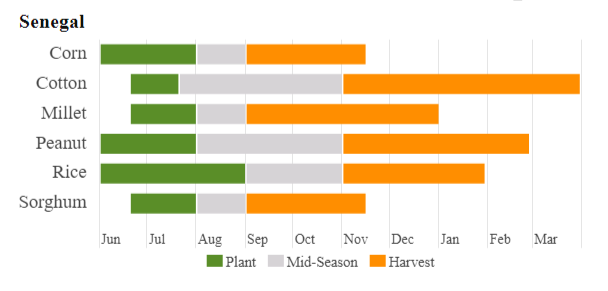
Main Season Crop Calendar: USDA Foreign Agricultural Service
Primary crops
The list of crops available in the FDW for download for Senegal (along with their French names and crop codes) is shown below:
Crop Name | French Name | CPCv2 Crop Code |
|---|---|---|
Maize (Corn) | Mais | R01122AA |
Rice (Paddy) | Riz | R01132AA |
Sorghum | Sorgho | R01142AA |
Millet (pearl) | Mil | R01182AD |
Fonio | Fonio | R01190AB |
Watermelon | Pasteque | R01221AA |
Eggplant | Aubergine | R01233AA |
Tomato | Tomate | R01234AA |
Okra | Gombo | R01239AA |
Oignon | Onion | R01253AA |
Melonseed | Beref | R01260AA |
Groundnuts | Arachide | R01422AA |
Sesame Seed | Sesame | R01444AA |
Sweet Potato | Patate | R01591AA |
Cassava | Manioc | R01592AA |
Bissap | Bissap | R01620AF |
Cowpeas | Niebe | R01706AA |
Cotton | Coton | R01921AA |
Production systems
The crop statistics available from DAPSA provide some production system information regarding irrigated and river recession crops, but this is not consistent over time.
Methodology
Methods
The Annual Agricultural Survey (EAA) is carried out during the agricultural cropping year in Senegal (July through June of the next year). The objective of this survey is to estimate the level of agricultural production coming from small holder-type farming systems. The survey also furnishes information on the physical characteristics of farmed land (geographic location, area exploited) and the nature of major investments made in this sector (inputs, farming activities, management and restoration of soils). The EAA uses the recognized integrated agricultural survey approach described as the 50 by 2030 Approach.
Geographic Coverage
The EAA covers all households and farmed areas in the 14 regions and 46 departments of the country.
Sampling
The EAA uses a two-stage sample with census districts in the primary stage and farming households in the second, as they have been defined in the most recent census of population, housing, agriculture and livestock-raising (RGPHAE).
The first-stage stratification includes 4 strata:
Rainfed farming only
Livestock-raising only
Gardening, fruit trees and forestry
Mixed rainfed farming and livestock-raising
The theoretic national-level sample totals 7,450 households in 1,460 census districts, with 5 households per census district.
More detail may be available from the National Archive of Senegalese Data (ANADS).